Maritime uses are not optional amenities
Sausalito trades concepts for engineering. Here's how.
Autumn 2025, Sausalito received the draft Shoreline Adaptation Plan. It showed the marinas underwater. It also proposed floating parking lots and a floating road. It blocked public access. It carried no cost estimate and no economic analysis.
SSWA members read all 168 pages. We wrote letters. We spoke at the meetings. We organized and showed up for waterfront businesses.
KC Pederson, a third-generation marine operator and SSWA member told the Council in November:
“The plan shows, in all three scenarios, our marina and all it’s businesses underwater and we were never met with.
After reviewing these options I need to say clearly: if any of these move forward, the maritime industry and Sausalito will not survive.
Maritime uses are not optional amenities. They are the foundation of the waterfront’s identity, economy, and
culture.”
The City Council listened. Unanimously, they sent the 168-page draft back as incomplete. Staff got new orders: analyze the economics, price out engineering that holds the line, keep the bill off residents, and put waterfront businesses in the room. Instead of wasting time and money on impractical revisions, Sausalito is now investing in proven engineering.
We deeply appreciate the Council’s vote and will continue working alongside the City’s Sea Level Rise Task Force, engineering experts, and community partners to deliver practical, science-based, and environmentally sustainable shoreline protection.
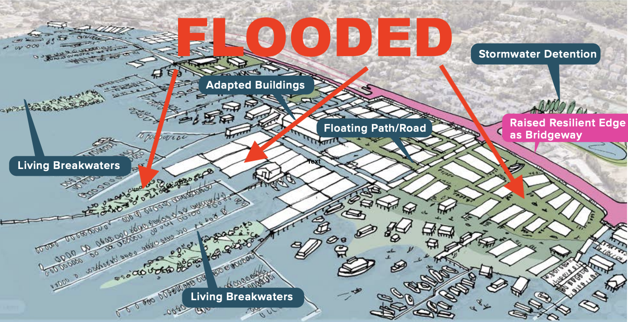
Flooded shoreline image sourced from draft Shoreline Adaptation Plan
By November 2025, planning consultants had spent roughly $500,000 on a draft that offered no engineering analysis, no cost estimates, no funding strategy, and no local tidal or wave data. When they returned in May 2026 requesting an additional $120,000 on the same terms, Jim Madden, fourth generation of Sausalito Yacht Harbor, offered a more efficient alternative:
“The scope continues to treat protecting our waterfront as just one scenario among many, even though this Council made clear that preserving our shoreline is the priority.
We need results, not more process. For just $10,000 to $20,000, we could install monitoring equipment to gather real wave data and make informed decisions.
If our goal is to hold the line, we should work with a consultant who shares that objective.”
The Council agreed and that alignment between waterfront voices and city leadership made the difference. Sausalito hired civil engineers Freyer & Laureta on a scope shaped collaboratively with SSWA, local agencies, and waterfront businesses.
Less money than the consultants requested, and it delivers something far more useful: a LiDAR survey of the full shoreline, five priced protection strategies, and real cost estimates from marine contractors who have built on this waterfront.
Local data beats regional averages
King tides put water in our streets eight to ten times a year. Twelve or thirteen when the rain comes with them. Storm waves come over the highway. This was never an argument about whether the Bay is rising. It is. The argument is about what Sausalito does next.
The draft plan applied a single storm surge estimate to all of Sausalito. Downtown, Swede's Beach, and the marinas behind their breakwaters all got the same figure. Anyone who works this water knows better. Sausalito juts into the Bay, and certain storm winds get miles of open water to build energy before they reach us. Where you sit changes what hits you. BCDC's own guidelines say local data beats regional averages. So SSWA members offered to collect it, placing monitoring equipment on our own boats, docks, pilings, and shorelines. The city pays nothing.
City staff are stretched thin and coastal engineering is not their day job. Nobody should expect it to be. But our members have read these tides for a hundred years. Now we put instruments on that knowledge and make it official.
There are four ways to hold a shoreline. Gray infrastructure: seawalls, levees, tide gates. Green: oyster beds, living shorelines, horizontal levees. Accommodation: elevating structures and land, which our floating home community has been doing since before anyone called it adaptation. And retreat.
No single tool works alone. Every one has a design life, and nature-based measures blunt storm surge but not permanent rise. Serious plans layer them, modular, extending as the water comes. SSWA supports the whole toolkit. Every tool but one.
A boatyard cannot move uphill. A marina cannot exist inland. For a town pinned between the hills and the Bay, retreat is not adaptation. It is abandonment, and it comes with the largest tax bill in Sausalito's history: miles of road, sewer, water, storm drain, and power, torn up and moved.
What the engineers do next
Fly the entire shoreline with drone LiDAR and map exact elevations.
Put sensors in the water so the models match what actually happens here.
Design five protection strategies and score each on cost, constructability, and permitting.
Price them with marine contractors who have built on this waterfront.
Take it to BCDC early, so permitting problems surface now instead of in year six.
The plan changed because people showed up for our waterfront. Join SSWA. [LINK HERE … HOW DO WE WANT TO DO THIS]
-
168 Page Shoreline Adoption Plan https://www.sausalito.gov/city-government/hot-topics/sea-level-rise/shoreline-adaptation
WRT Sea Level Rise Adaptation Plan for Sausalito https://legistarweb-production.s3.amazonaws.com/uploads/attachment/pdf/2937345/Attachment_1_-_2023_WRT_Consulting_Approved_Scope_of_Work.pdf
F&L scope of work, City of Sausalito agenda attachment https://granicus-aasmp-peak-files.s3.amazonaws.com/uploads/attachment/pdf/4108690/Attachment_1-_Draft_Scope_of_Work_prepared_by_Freyer___Laureta.pdf?X-Amz-Algorithm=AWS4-HMAC-SHA256&X-Amz-Credential=AKIATHOFOHMMEOCNXD2W%2F20260722%2Fus-east-1%2Fs3%2Faws4_request&X-Amz-Date=20260722T230533Z&X-Amz-Expires=3600&X-Amz-SignedHeaders=host&X-Amz-Signature=5df2eaa159485a08c00738ddbc25a826b4a7312e9e987edcb04f234446e663b0
Sausalito Sea Level Rise Page https://www.sausalito.gov/city-government/hot-topics/sea-level-rise
City Council Meeting — Tuesday, November 18, 2025: 5.C Receive and File the Shoreline Adaptation Plan and Provide Direction for Next Steps https://sausalito.granicus.com/player/clip/1817?view_id=6&redirect=true
City Council Meeting — Tuesday, May 20, 2025: 3.F) Receive and File the Shoreline Adaptation Plan Update & 3.G) Authorize the City Manager to Execute the First Contract Amendment with WRT Consulting to Provide Additional Planning Services for the Shoreline Adaptation in the Amount of $40,000 Supported by the Sea Level Rise Planning Grant https://sausalito.granicus.com/player/clip/1778?view_id=6&redirect=true
City Council Meeting — Tuesday, April 7, 2026: 3.C) Authorize the City Manager to Execute a Second Contract Amendment with WRT Consulting to Provide Additional Planning Services for the Shoreline Adaptation Framework in the Amount of $120,000 Supported by the Sea Level Rise Planning Grant https://sausalito.granicus.com/player/clip/1867?view_id=6&redirect=true